Active weather returns with wintry impacts for northern Oklahoma

Good morning Oklahoma! Across the state, residents are waking up to freezing conditions.
What is the weather like on Monday?
Precipitation is expected to begin as rain later on Monday and spread south of I-44 through the evening.
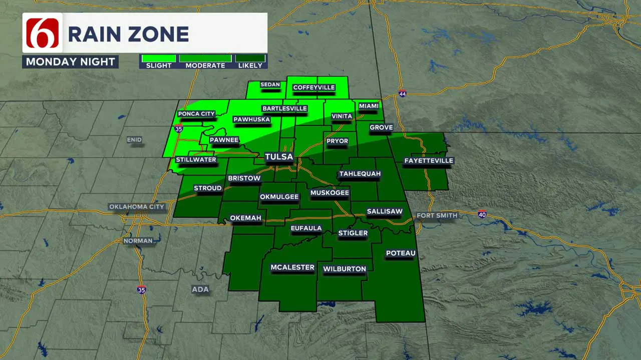
A series of cold fronts will bring progressively colder weather throughout the week.
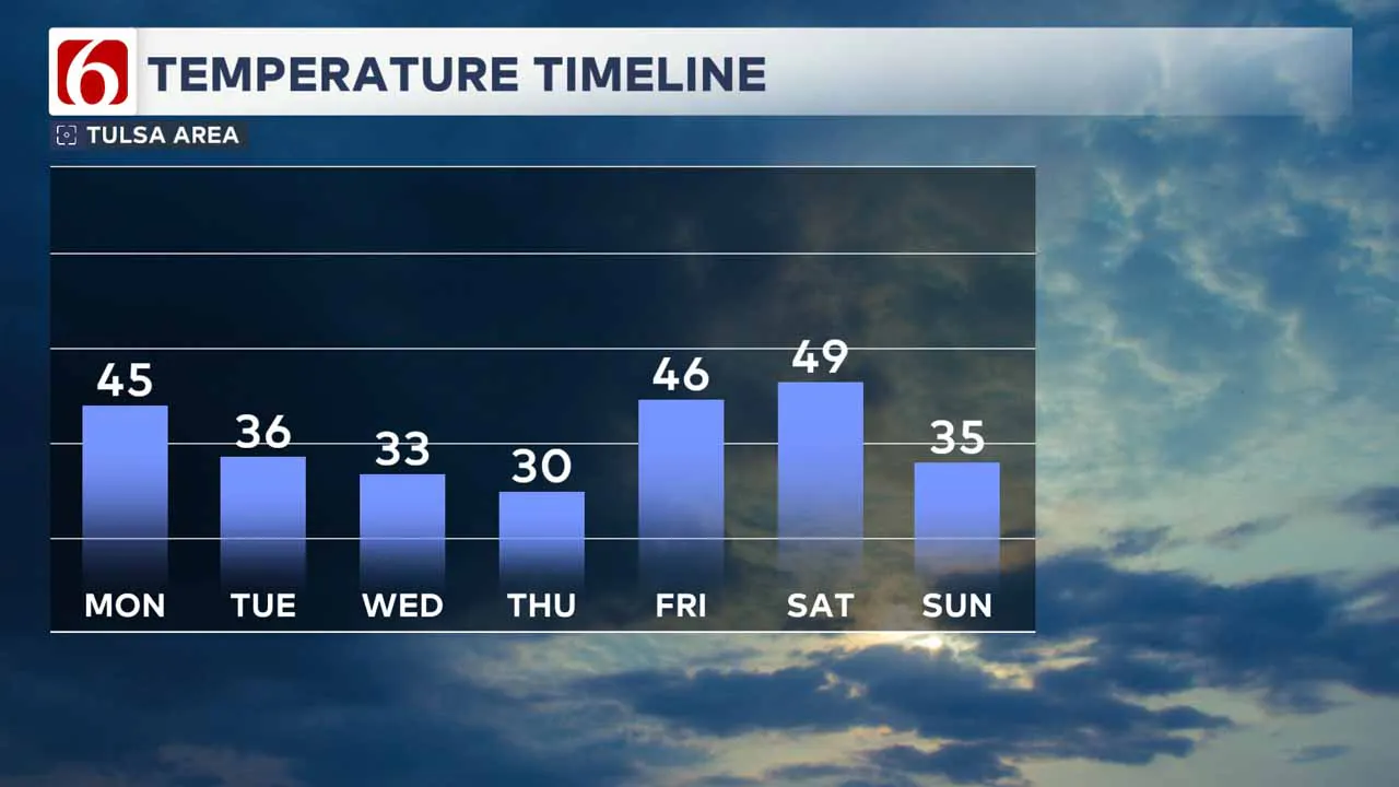
On Monday, temperatures will reach the mid-40s for many locations, with increasing clouds and east-southeast winds at 10 mph.
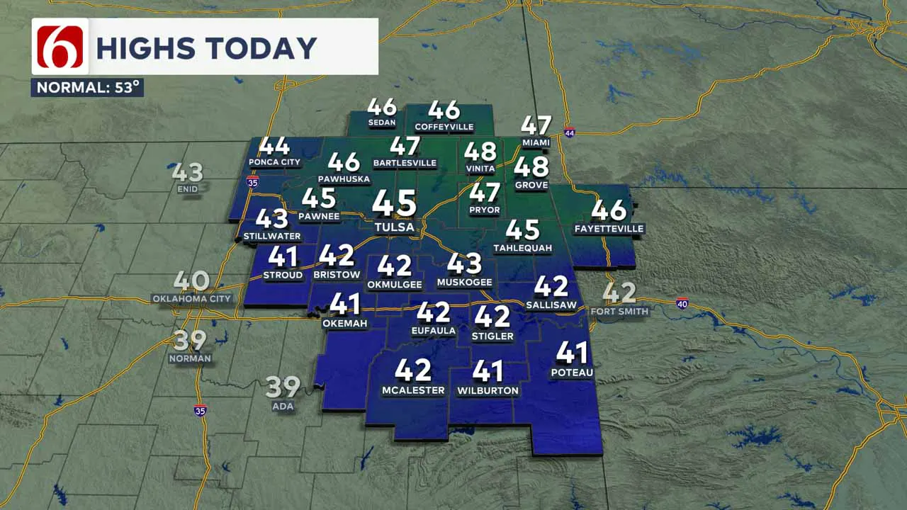
Several disturbances will pass near and over our region, increasing the likelihood of precipitation, including potential wintry weather.
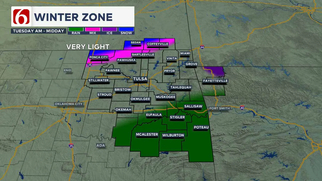
Most of the precipitation Monday afternoon and evening will be light rain, with a small area of wintry precipitation possible Tuesday morning along the Oklahoma-Kansas state line.
A second, more impactful wave is expected late Wednesday, and another system may bring showers to the area on Saturday.
When Can We Expect Rain?
Temperature profiles will remain above freezing late tonight into early Tuesday morning, ensuring the precipitation remains liquid for most areas.
However, higher elevations of northwestern Arkansas will see light freezing rain early Monday night into Tuesday morning.
The Oklahoma-Kansas state line region could also experience a wintry mix or snow due to colder temperatures.
This first wave will quickly move eastward, and precipitation should end by early Tuesday morning.
When is the Best Chance for Wintry Weather?
The best chance for wintry weather will return Wednesday as colder air arrives with an additional disturbance.
Early Wednesday, precipitation will likely develop and intensify. The specific areas for rain, freezing rain, sleet, and snow will become clearer as more data arrives.
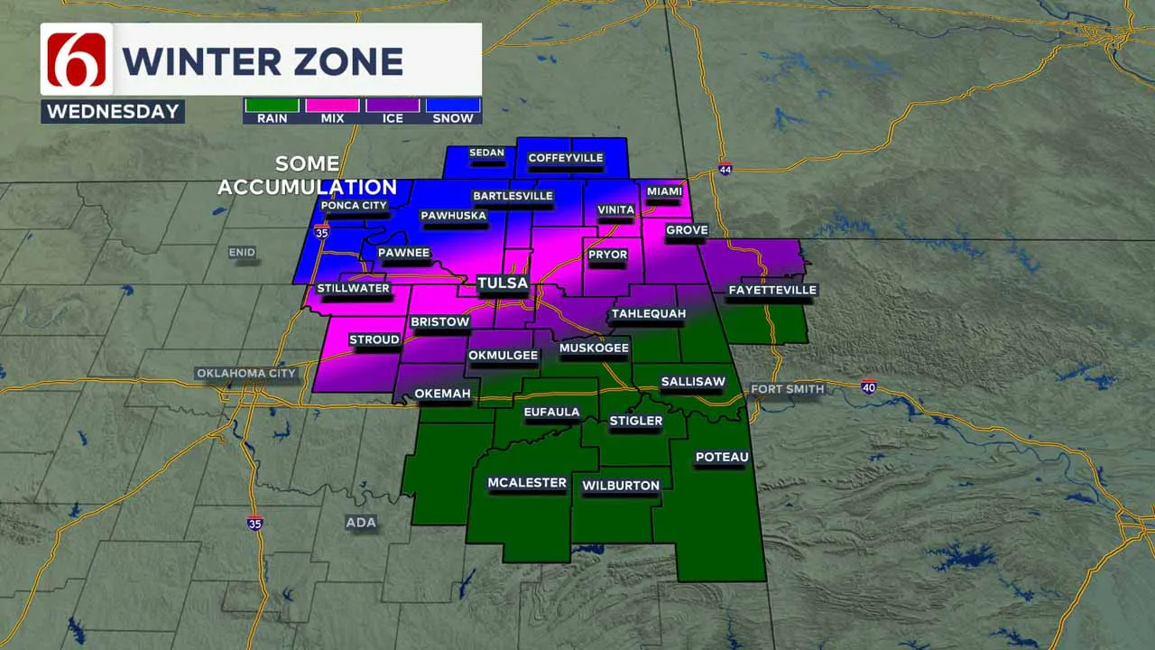
Projections suggest that areas along and northwest of I-44 may experience rain transitioning to light freezing rain early Wednesday morning, followed by sleet and snow by midday into early afternoon.
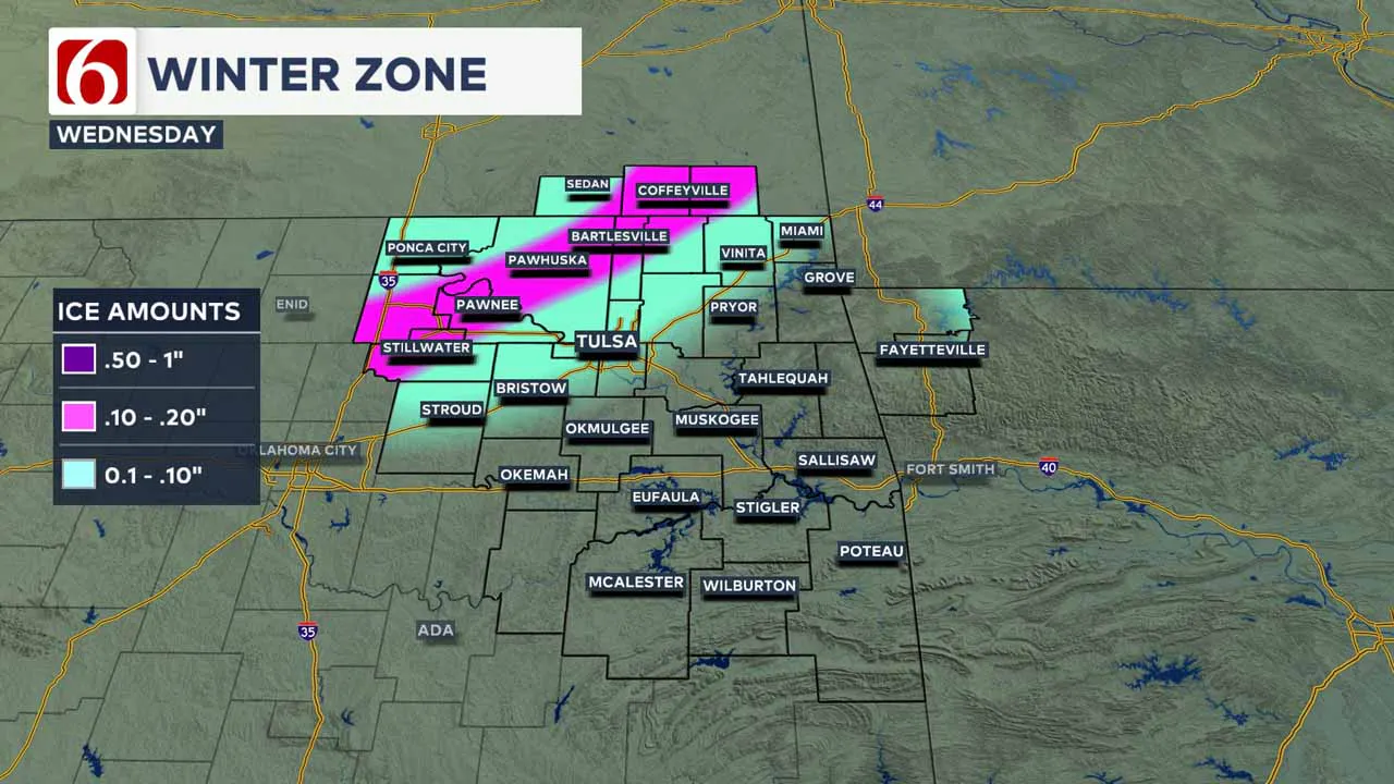
Areas to the north-northwest, including far northern Oklahoma and southern Kansas, may see a mixture of sleet and snow. Locations further south, mainly along the I-40 corridor, will likely remain rainy.
How Much Wintry Precipitation Could We Receive?
The first wave, moving across southern Kansas early Tuesday morning, will bring light precipitation.
The second wave arriving Wednesday morning, however, may produce slightly higher amounts.
Precipitation types could lead to slick conditions on streets, overpasses, and bridges, particularly along and northwest of I-44.
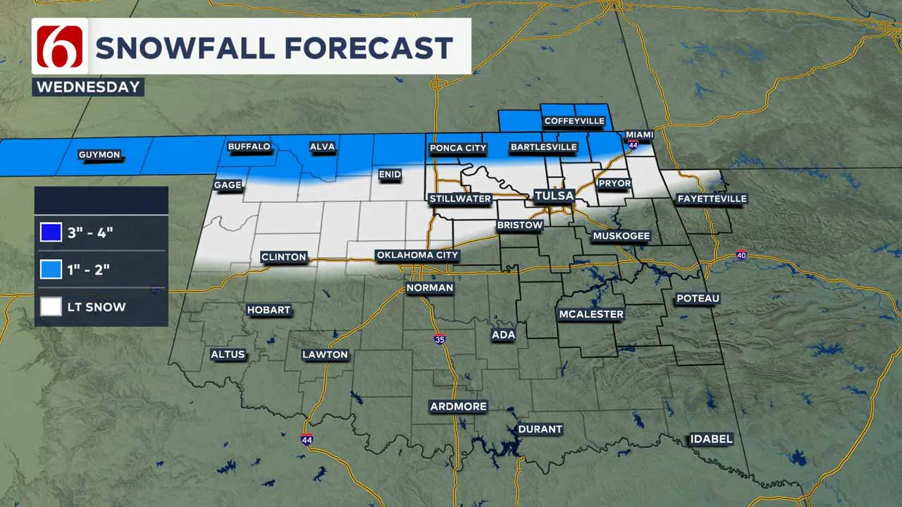
This may warrant a winter weather advisory rather than a winter storm warning. Areas from south-central to northeastern Kansas, including Wichita and Kansas City, may approach winter storm warning criteria on Wednesday.
Another wave may bring light flurries late Thursday. We could see a light glaze of ice along and northwest of I-44, with a wintry mix of light snow near 1 inch in the metro and 2 inches along the OK and Kansas state line region.
Temperature Forecast
By Tuesday morning, temperatures along the Oklahoma-Kansas state line will dip below freezing.
Afternoon highs on Tuesday will be in the lower to mid-30s to the north and lower 40s to the south before dropping further with a strong cold front and gusty north winds.
Wednesday morning lows will be in the upper 20s, with highs only reaching the lower 30s.
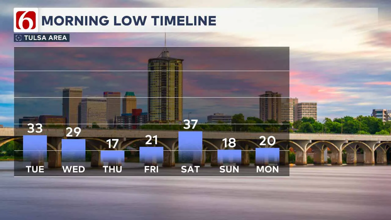
Thursday will start with temperatures in the mid-teens, and highs will remain near or below freezing throughout the afternoon.
Friday morning will start near 20°F, with a high of 46°F. Saturday morning will bring temperatures around 37°F, with highs near the upper 40s before another round of showers and colder weather arrives Saturday night into Sunday.
Sunday morning lows will be in the upper teens, with afternoon highs in the mid-30s.
———
Winter Weather Preparation:
Where are the warming shelters available in Tulsa this year?
The city of Tulsa, local shelters, warming stations, and outreach teams are working to ensure access to safe, warm spaces during the cold temperatures.
>>> City of Tulsa prepares for extreme cold temperatures
>>> Warming Shelters Open Across Tulsa Amid Freezing Temperatures
Tulsa shelters and temporary warming locations are open to provide refuge. Major locations include:
- John 3:16 Mission, 506 N. Cheyenne — Open 24/7
- The Salvation Army Center of Hope, 102 N. Denver Ave. — Open 24/7
- Tulsa Day Center, 415 W. Archer St. — Open 24/7 (Pets allowed, limited capacity)
- Youth Services of Tulsa, 311 S. Madison Ave.
Temporary overflow shelters will also be open for the cold weather:
- The Merchant: 605 S. Peoria Ave., open Monday, Jan. 20, 9 a.m.–Noon; Tuesday-Friday, 9–11 a.m.
- Denver Avenue Station: 319 S. Denver Ave., open Sunday, 8:30 a.m.–8:30 p.m.; Monday-Saturday, 5:30 a.m.–11:30 p.m.
- The Station at Youth Services: 311 S. Madison Ave., open Monday-Friday, 11 a.m.–4 p.m.
- Iron Gate: 501 W. Archer St., open daily, 8:30–10:30 a.m.
- The Ministry Center: 312 S. 33rd W. Ave., open Tuesday-Thursday, 9:30 a.m.–1 p.m.
For a full list of warming station locations and hours, visit Housing Solutions’ Winter Weather Information Page.
>>> Warming Shelters, Safety Tips For Cold Temperatures This Winter In Oklahoma
Bring Pets Inside!
Winter temperatures can pose additional challenges for pets, particularly older animals or those with health conditions. Hartfield recommends:
- Wellness Checks: Ensure pets are up to date on vaccines and discuss arthritis or other cold-weather health concerns with a veterinarian.
- Outdoor Time: Monitor the duration of outdoor activities, especially for short-haired breeds or pets with conditions like diabetes or heart disease.
- Paw Care: After walks, inspect and clean paws to remove ice or de-icing chemicals that could harm your pet.
>>> Cold Weather Pet Tips: How To Keep Animals Safe During Winter Months
How Can I Protect Myself From Sickness This Winter?
The Tulsa Health Department is urging residents to receive flu and COVID-19 vaccinations to prevent respiratory illnesses as Oklahoma enters the coldest months of the year.
- Health experts say the risk of respiratory illnesses is higher during the winter, as colder weather often leads to more indoor gatherings, increasing the likelihood of viruses spreading.
- The Centers for Disease Control and Prevention says Oklahoma is one of 11 states with very high respiratory virus activity, and with flu vaccination rates lower than this time in 2024, more people have reported getting sick.
>>> How to Protect Yourself From Respiratory Illness This Winter
Emergency Info: Outages Across Oklahoma:
Northeast Oklahoma has various power companies and electric cooperatives, many of which have overlapping areas of coverage. Below is a link to various outage maps.
>>> Tulsa HVAC, Plumbing Companies Flooded With Calls During Cold Weather
- PSO Outage Map
- OG&E Outage Map
- VVEC Outage Map
- Indian Electric Cooperative (IEC) Outage Map
- Oklahoma Association of Electric Cooperatives Outage Map — (Note Several Smaller Co-ops Included)
The Alan Crone morning weather podcast link from Spotify:
https://open.spotify.com/show/0dCHRWMFjs4fEPKLqTLjvy
The Alan Crone morning weather podcast link from Apple:
Follow the News On 6 Meteorologists on Facebook!
- Meteorologist Travis Meyer
- Meteorologist Stacia Knight
- Meteorologist Alan Crone
- Meteorologist Stephen Nehrenz
- Meteorologist Aaron Reeves
- Meteorologist Megan Gold
